New Views of Old Waters: Archived NOAA Charts
NOAA placed online its library of historical charts, historical to us primarily because the charts are shorn of the level of detail we have expect from modern charts. We get a look at how our waters were represented to fishermen, packet clippers, trade shipping interests during previous centuries.
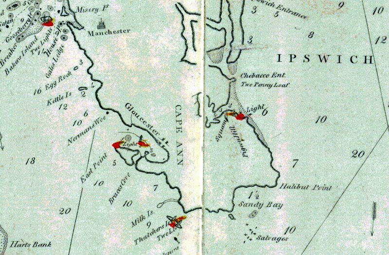
Here is a mid-nineteenth century version of a chart section of Gloucester, Massachusetts.
At the time of this chart's printing, Gloucester was one of the world's busiest fishing ports. Its fleet of fishing schooners numbered in the thousands.
To enlarge this charming piece of art, click on it.
Pretty humble art for what was at that time a busy port whose fishing made past the northeastern tip of Cape Ann for fishing grounds to the east and north:
 There's a lot to note here. One is that Eastern Point was once called East Point, and lacked the long breakwater which gives Gloucester an inner and an outer harbor.
Another is that the lighthouse at Eastern Point, and the light atTen Pound Island in the inner harbor, were lit with flash patterns the chart doesn't delineate.
There are also no channel markers, reminding us that nineteenth-century skippers piloted their boats in tight waters by way of compass, lead, and ranges.
We can also note that even then, nearly two centuries back, the spelling of Thachers Island was a matter of confusion, and that the island already had the two lighthouses which when lined up indicate true north and south.
Lookingt at nearby Rockport, we see that the present-day offshore breakwater in Sandy Bay's northeast corner hadn't been built by its consortium of investors, and that the offshore Salvages, a bastardization of the French Sauvages, had then as now a deep passage between its ledges.
Finally we note that Rockport Harbor, a granite-block construct, didn't exist. Water depth data is minimal, colors muted. This was all that a prudent and seasoned mariner needed: red ticks for lights to make when returning to port, marks of shoals to avoid, a few basic land contours and the names of local landmarks. Charming now, an invaluable document then.
It's a simple matter to fetch NOAA's database of antique nautical charts. You'll need to use NOAA's SID to enlarge the scanned high resolution images.


Comments